
GIS-RIS Map Creation
GIS-RIS Map Creation
Spatial data visualization is a cornerstone of environmental, geographical, and field-based studies. Dr. Arup Giri’s GIS-RIS Map Creation Service transforms your raw sampling coordinates into professional, high-resolution color gradation maps and heatmaps that elevate the scientific rigor of your manuscript.
We process your GPS coordinates, location data, and mean results against standard comparison levels to generate accurate, visually striking spatial representations of your study area.
journals and societies recommend
0
+
field-specific topics in study
0
+
authors served
0
+

Why it matters
Reviewers rely on clear visual data to understand the geographical context of your research. Imprecise, poorly scaled, or visually confusing maps can obscure critical spatial trends and diminish the perceived quality of your methodology. Professional GIS mapping demonstrates meticulous data collection and analytical capability.
Our process includes
- Custom Spatial Plotting: : Accurate mapping of sampling locations using your provided coordinates.
- Color Gradation/Heatmaps:Visualizing mean values against standard levels for impactful comparison.
- Publication-Ready Resolution: Maps optimized for journal layout and aesthetic requirements.
- Tiered Pricing: ₹499 for 1 to 5 maps; ₹999 for 6 to 10 maps.
- Submit your raw data files(Excel/CSV) via the submission option.
- Then complete all the follow-up processes
- I will revert to you with the final high-resolution maps within three working days from the day of submission.
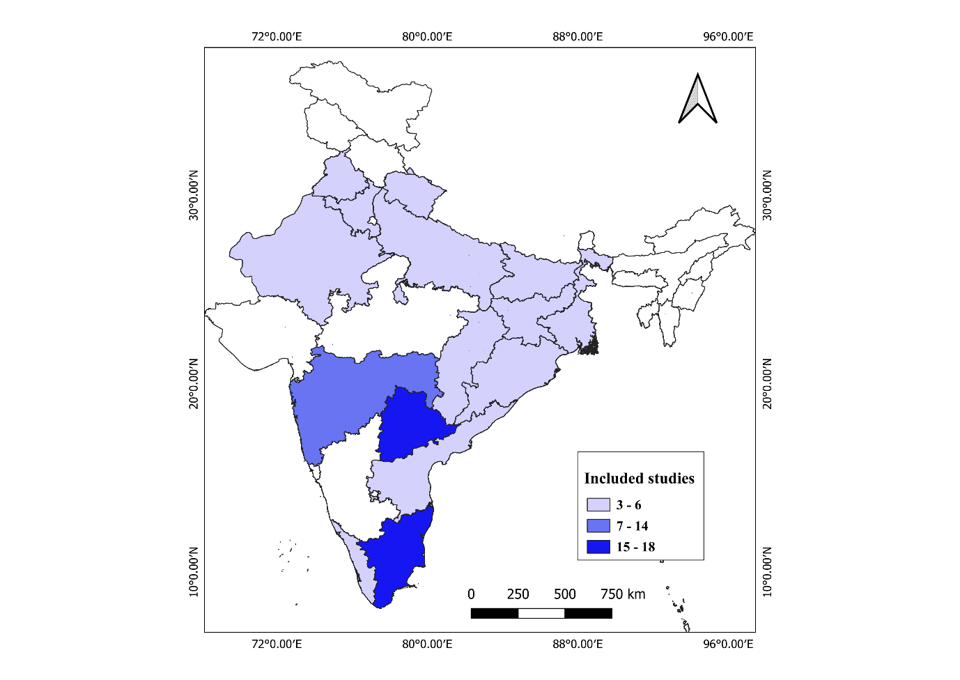
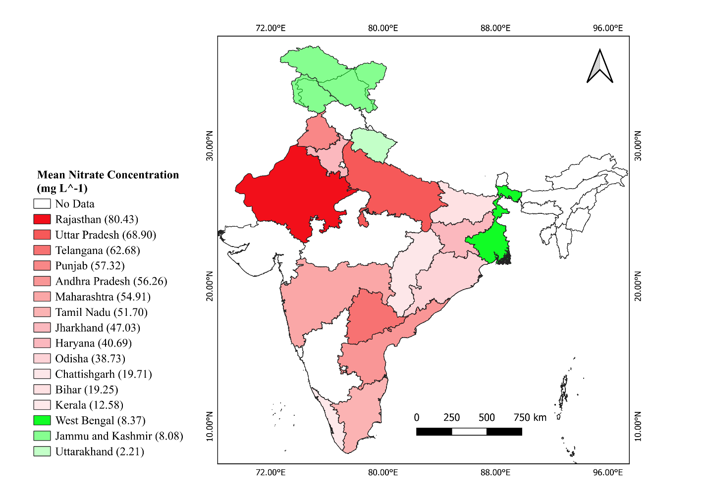
Sample copy-RIS-GIS Map
Frequently asked question
Q1. What data must I provide for GIS/RIS Map Creation?
You must provide the coordinates of sampling locations, the location names/details with mean values of results, and the standard levels for comparison so our team can accurately create the color gradation maps.
Q2. What is the pricing and turnaround time for GIS/RIS Maps?
Delivery is within three (3) working days. The pricing is tiered: ₹499 for 1 to 5 maps, and ₹999 for 6 to 10 maps.
Q3. Is my manuscript and research data kept strictly confidential?
Yes, absolutely. We maintain strict confidentiality protocols for all submitted research. Your files are handled securely, never shared with third parties, and are permanently deleted from our active servers shortly after your order is successfully fulfilled.
Q4. What currency are your prices listed in?
All prices on our platform are listed in Indian Rupees (INR) (₹).
Q5. What if I have a very large manuscript or need bulk services not covered by the standard pricing tiers?
If your manuscript exceeds the maximum page limits listed (e.g., a thesis over 300 pages for editing, or requiring more than 10 GIS maps), please use our “Contact Support” option. We will review your specific requirements and provide a custom, tailored quote.
Our Guarantee
Spatial Precision
We guarantee exact plotting of your sampling locations based strictly on the GPS coordinates you provide.
Publication-Ready Resolution
We guarantee all color gradation and heatmaps will meet the high-resolution, aesthetic standards required by top-tier journals.
Timely Delivery
We guarantee your finalized spatial maps will be delivered within three (3) working days.

GIS-RIS Map Creation Order Form
Submit your coordinates and research data to receive high-quality GIS/RIS maps customized for academic publications and research projects.
Terms and Conditions: GIS/RIS Map Service
Welcome to Outreach Services by Dr. Arup Giri (https://arupgiri.com). The following Terms and Conditions govern your use of our Geographic Information System (GIS) and Risk Information System (RIS) mapping service. By commissioning a GIS/RIS map from our team, you explicitly agree to the terms outlined below.
1. Description of Service
Our GIS/RIS Map Service provides customized, high-resolution digital mapping that layers geographic baseline data (e.g., topography, road networks, population density) with specific risk or hazard data (e.g., flood zones, disease outbreaks, pollution levels, or seismic activity). This service is designed to help researchers, planners, and academics visualize spatial relationships and pinpoint danger spots for inclusion in research publications, theses, or academic presentations.
2. Client Responsibilities and Data Provision
To generate an accurate spatial analysis and map, we require specific inputs from the client:
- Study Area: Clearly defined geographic boundaries (e.g., specific coordinates, city limits, or regional shapefiles).
- Data Sources: Clients must provide the raw risk data (e.g., Excel sheets with GPS coordinates of disease cases) or direct us to the specific open-source databases (e.g., government census data, USGS, WHO) they wish us to utilize.
- Specific Variables: Clear instructions on which layers need to be visualized and how they should be weighted or categorized.
3. Academic Use and Disclaimer of Real-World Liability (Crucial)
Please read this section carefully:
- Research Purposes Only: The GIS/RIS maps generated by Outreach Services are strictly intended for academic research, peer-reviewed publication, and theoretical planning purposes.
- Not for Emergency Response: Our maps are not real-time navigational tools, legal land surveys, or operational emergency response systems.
- No Public Safety Liability: Dr. Arup Giri and Outreach Services assume absolutely no liability for real-world property damage, physical injury, or financial loss resulting from decisions made based on the hazard zones, risk assessments, or geographic boundaries depicted in our maps.
4. Data Accuracy and Integrity
- "Garbage In, Garbage Out": Our GIS experts visualize the data provided to them. We do not conduct field surveys to ground-truth coordinates, nor do we independently verify the accuracy of third-party risk datasets. The scientific and geographical accuracy of the final map is entirely dependent on the quality of the raw data provided by the client.
- Legal Acquisition: By providing datasets to Outreach Services, you warrant that you have obtained the data legally and possess the necessary rights or permissions to use it for spatial analysis.
5. Deliverables and Revisions
- Output Formats: By default, final maps are delivered as high-resolution image files (e.g., 300–600 DPI .TIFF, .JPEG, or .PNG) optimized for journal publication. If you require raw GIS files (such as ESRI Shapefiles or GeoTIFFs), this must be requested at the time of ordering and may be subject to additional fees.
- Revision Policy: The base fee includes one (1) round of minor revisions (e.g., altering color ramps, adjusting legend text, or zooming in/out of the layout). Adding completely new data layers or changing the primary study area after the initial map is drafted constitutes a major revision and will incur additional charges.
6. Copyright and Ownership
Upon final delivery and full payment, all copyrights to the specific customized map images are transferred to you for publication and presentation. Outreach Services retains no ownership over your proprietary data. However, we reserve the right to retain the underlying working project files unless explicitly requested and agreed upon.
7. Limitation of Liability
- Outreach Services cannot guarantee that the inclusion of our GIS/RIS maps will result in the acceptance of your manuscript by any academic journal.
- In no event shall the total liability of Dr. Arup Giri or Outreach Services for any claims related to this mapping service exceed the total amount paid by the user for the specific GIS/RIS order.
8. Modifications to Terms
Dr. Arup Giri reserves the right to modify these Terms and Conditions at any time. Changes will be effective immediately upon posting to arupgiri.com. Continued use of the service constitutes acceptance of any modified terms.